
Pella Strand found the end of the river on Thursday morning, though “found” may be too dramatic a word for a woman who has spent three weeks crawling through a brick-lined tunnel with a tape measure and a lantern. She followed the water, as she has been doing since early February, and the water led her — as water always does — downhill, toward the Ashwater.
The buried conduit that Strand discovered beneath the Docklands in February — the one that appears on no known city map, the one that she named, in a phrase that has acquired a certain civic poetry, “the river nobody named” — emerges into the Ashwater through a stone-arched outfall beneath the old commercial wharf at Bramblegate Steps.
The same wharf that, as of 6:00 AM on Friday morning, serves as the southern terminal of the emergency Ashwater ferry.
“I was approximately ten metres from the river when I heard the horn,” Strand said, with the particular amusement of a person who has spent three weeks underground and emerged into somebody else’s news story. “The ferry’s first crossing. I was below the wharf at the time. The sound travels very well through stone.”
The Outfall
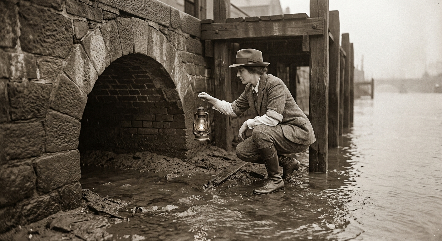
The conduit’s terminus is a vaulted stone opening approximately 1.6 metres wide and 1.2 metres tall, set into the river wall below the wharf’s timber decking. It has been partially silted over — decades of river sediment have reduced the effective opening to roughly half its original dimensions — but water continues to flow through it, as it has done, by the evidence of the mason’s marks, since 1782.
From the riverbank, the outfall is invisible. The wharf’s pilings and the river wall’s granite facing conceal it entirely. It was only accessible from within the conduit itself, which Strand entered from a survey shaft near Harrowgate Pier and followed downstream for the final 130 metres on Thursday.
“The conduit is in excellent condition along its entire length,” Strand reported to Chief Municipal Engineer Dorothea Kinnear on Friday. “The brickwork is intact. The arching is sound. The flow is steady and the water is clean — still fed, as far as I can determine, from the Ashwater’s upper tributaries through a catchment system that predates the city’s formal drainage by nearly fifty years.”
Strand has now mapped 780 metres of the system — from its earliest discovered point near Harrowgate Pier, running east-west beneath Chandler’s Row, Pilot’s Alley, and the lower Harbourfront Parade, to its emergence beneath Bramblegate Steps.
What It Means
The immediate question is structural. The wharf at Bramblegate Steps — a timber-and-stone structure of uncertain vintage, now bearing the weight of a floating pontoon, a ticket office, and several thousand daily commuters — sits directly above a watercourse that has been flowing beneath it for more than two centuries.
Kinnear, when informed of the outfall’s location, ordered an assessment of the wharf’s foundations.
“The fact that the conduit has been flowing beneath the wharf without incident for over two hundred years is, in itself, reassuring,” Kinnear said. “But we are now placing new loads on that structure — the pontoon, the mooring equipment, the foot traffic — and we need to understand the interaction between the conduit’s flow and the wharf’s pilings. I have asked Strand to include a foundation survey in her report.”
Strand said the conduit appeared to pass approximately three metres below the wharf’s deck level, with the pilings driven into clay on either side of the arched channel. “The builders of the wharf almost certainly knew the conduit was there,” she said. “The pilings are placed to avoid it. Someone, at some point, told someone else. And then everyone forgot.”
The Historical Record
Louisa Marchbank of the Bobington Historical Preservation Society, who identified the 1793 reference to “the lower conduit” in the Harbourmaster’s journal, said the outfall’s location was consistent with the journal’s description of a waterway “which serves the dock warehouses with fresh water and empties into the river at the Steps.”
“At the Steps,” Marchbank repeated. “It was in the journal all along. We simply did not know which steps.”
The conduit’s original purpose — supplying fresh water to the dockside warehouses before the municipal water system was established in the 1830s — explains both its construction and its subsequent obscurity. Once the municipal system made it redundant, the conduit continued to flow but ceased to matter, gradually vanishing from institutional memory and cartographic record.
“Two hundred and forty-four years,” Strand said. “This waterway has been delivering fresh water to the Docklands for two hundred and forty-four years, and nobody has checked on it since the Harbourmaster wrote it down in 1793. It has been doing its job better than most things in this city.”
Strand’s full survey report is expected by the end of March. The Bobington Historical Preservation Society has formally requested that the conduit be considered for heritage listing.