
A routine municipal survey of Bobington’s underground drainage has uncovered what appears to be a substantial buried waterway running beneath the Docklands — one that does not appear on any known map of the city’s infrastructure.
The waterway was discovered last week by Pella Strand, a 29-year-old surveyor with the Municipal Works Office, during a comprehensive mapping project of the city’s subsurface water systems. The project, commissioned six months ago by Chief Municipal Engineer Dorothea Kinnear, is intended to produce the first complete modern survey of Bobington’s underground hydrology — the network of buried streams, Victorian-era storm drains, and culverts that carry water beneath the city’s streets.
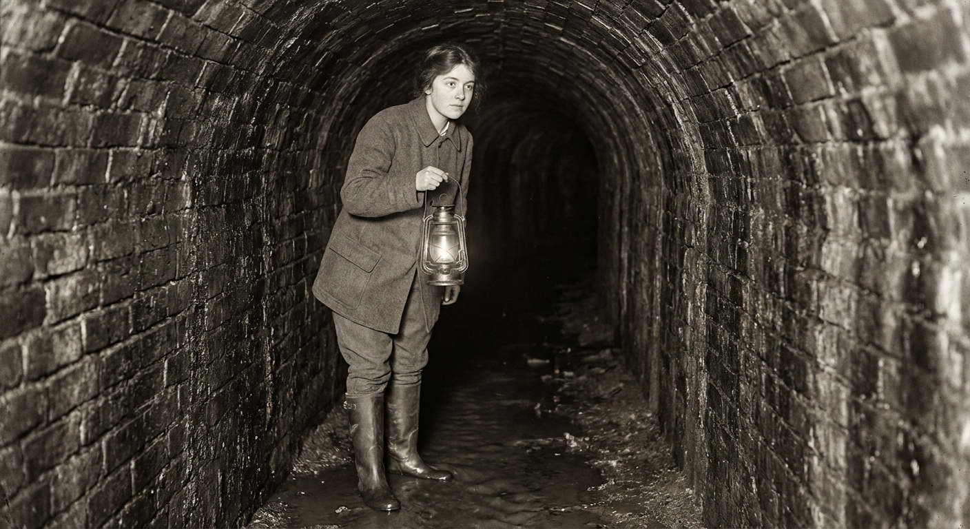
“We were mapping a known drainage culvert beneath Chandler’s Row when we found it,” Strand told The Bobington Times. “The culvert connects to a much larger passage — brick-lined, arched, roughly two metres wide and one and a half metres tall. It carries flowing water. It is clearly very old.”
An Absence on the Map
The passage runs roughly east-to-west beneath the Docklands, from a point near Harrowgate Pier toward the Ashwater. Strand’s team has traced approximately four hundred metres of it so far, using ground-penetrating survey equipment and two physical access points — one through the Chandler’s Row culvert and another through a collapsed inspection shaft behind a warehouse on Old Harbour Road.
What makes the discovery unusual is not its existence — old cities sit atop layers of forgotten infrastructure — but its complete absence from the historical record.
“Every culvert, every buried stream in the city is documented somewhere,” Strand said. “The Victorians were meticulous. The Municipal Works Archive has survey maps going back to the 1850s, and most of them are remarkably detailed — you can trace individual drain runs across entire districts. This waterway is not on any of them.”
Preliminary assessment suggests the passage predates the Victorian drainage system that surrounds it. The brickwork is of a type Strand described as “consistent with late eighteenth or early nineteenth century construction, possibly earlier,” though she stressed that she is a surveyor, not an archaeologist.
“I can tell you it’s old, it’s large, and it’s flowing,” she said. “I cannot tell you who built it or why."
"Not Unusual, But Not This”
Kinnear, the Chief Municipal Engineer who commissioned the survey, confirmed the discovery and said the Municipal Works Office was consulting with the Bobington Historical Preservation Society and the Royal Institute of Natural Philosophy to determine the passage’s age and origin.
“It is not unusual to find forgotten infrastructure during a comprehensive survey,” Kinnear said. “Bobington has been built, rebuilt, and built over for centuries. We find things — old cellars, abandoned sewers, the foundations of buildings nobody remembers.”
She paused.
“What is unusual is finding something of this scale that we have no record of at all. Four hundred metres is not a cellar. It is not a drain. It is a deliberate construction, built to carry a significant volume of water, and nobody wrote it down — or if they did, the record has not survived.”
The waterway’s eastern extent — near Harrowgate Pier — places it beneath one of the oldest parts of the Docklands, an area that was marshland before the harbour was developed in the late eighteenth century. Its western course appears to lead toward the Ashwater, though Strand has not yet traced it to its outlet.
“We know where it seems to be going,” she said. “We don’t know where it starts. The eastern end disappears beyond the range of our current equipment. We need to go further.”
History Underground
Louisa Marchbank, chairwoman of the Bobington Historical Preservation Society, expressed what she called “considerable interest” in the discovery.
“If this waterway predates the Victorian drainage system — and the preliminary description suggests it does — it could be one of the oldest surviving structures in the Docklands,” Marchbank said. “Possibly one of the oldest in the city.”
Marchbank noted that the Docklands area has a complex pre-industrial history that is poorly documented. Before the construction of the modern harbour in the 1790s, the waterfront district was a patchwork of marshland, tidal flats, and small wharves serving the river trade. Several streams and tidal channels once crossed the area before being diverted or buried during development.
“It is entirely plausible that one of those watercourses was enclosed rather than filled — canalised, effectively, and then buried as the district was built up around it,” she said. “But a brick-lined, arched passage suggests something more deliberate than simply covering a stream. Someone built this. The question is who, and when, and for what purpose.”
The Society has requested access to the site and offered to assist with historical research. Marchbank said she intended to consult the city’s pre-Victorian land records, held in the municipal archive, for any reference to the waterway.
The Surveyor
Strand, who joined the Municipal Works Office three years ago after studying civil engineering at Bobington Polytechnic, said she had been warned by colleagues that subsurface surveying was “the most boring job in the city.”
“They were wrong,” she said.
She described the moment of discovery — standing in the Chandler’s Row culvert with a colleague, surveying a junction point, and noticing that the water was flowing in an unexpected direction.
“Water flows downhill. You always know which way it should be going. This was going the wrong way — or rather, it was going a way that didn’t match the mapped gradient of the culvert system. We followed it, and the culvert opened into this much larger passage. The brickwork changed completely. You could see where the Victorian culvert had been punched through the wall of something older.”
She said the experience of standing in the passage — head torch on, water flowing past her boots, the sound of the city muffled overhead — was “the most interesting thirty seconds of my professional life.”
“You’re standing in something that nobody alive knows about,” she said. “That doesn’t happen in a city. Every pipe, every cable, every tunnel is supposed to be on a map somewhere. This one isn’t.”
What Comes Next
The comprehensive drainage survey is expected to continue through mid-March. Strand’s team is attempting to trace the waterway to its source, which current data suggests lies somewhere beneath the western Docklands, possibly near or beneath Port Sovereign — an area that was developed later and whose subsurface conditions are less well mapped.
Kinnear said the discovery would not delay the broader survey but had added “an unexpected dimension” to the project.
“We set out to map what we knew was down there,” she said. “We have found something we didn’t know was down there. That is, on balance, more interesting.”
Strand, asked whether she had a theory about the waterway’s purpose, shook her head.
“Theories are for people with more information than I have,” she said. “What I have is four hundred metres of brick tunnel, flowing water, and no map.”
She smiled.
“Somewhere under this city, there is a river that nobody named. I’d like to find out where it goes.”