
The cellar of The Old Cooperage has been dry for twenty years. Arthur Penrose knows this because he stores his winter ale there — sixty barrels at any given time, racked along the stone walls of a space that has served as a beer cellar, continuously, since the 1830s.
On Saturday morning, Mr Penrose descended the stairs and found three inches of water on the floor.
“I’ve had damp,” said Mr Penrose, who is fifty-seven and has owned The Old Cooperage for nineteen years. “Every cellar in this district has damp. This is not damp. This is a river.”
The water was clear, cold, and flowing — entering through a seam in the eastern wall and pooling against the opposite side, where a shallow drain, installed by a previous owner and long disused, was carrying it away at roughly the rate it arrived. The sixty barrels of winter ale were, Mr Penrose confirmed, above the waterline.
He contacted the Municipal Works Office on Monday. On Tuesday morning, Pella Strand arrived.
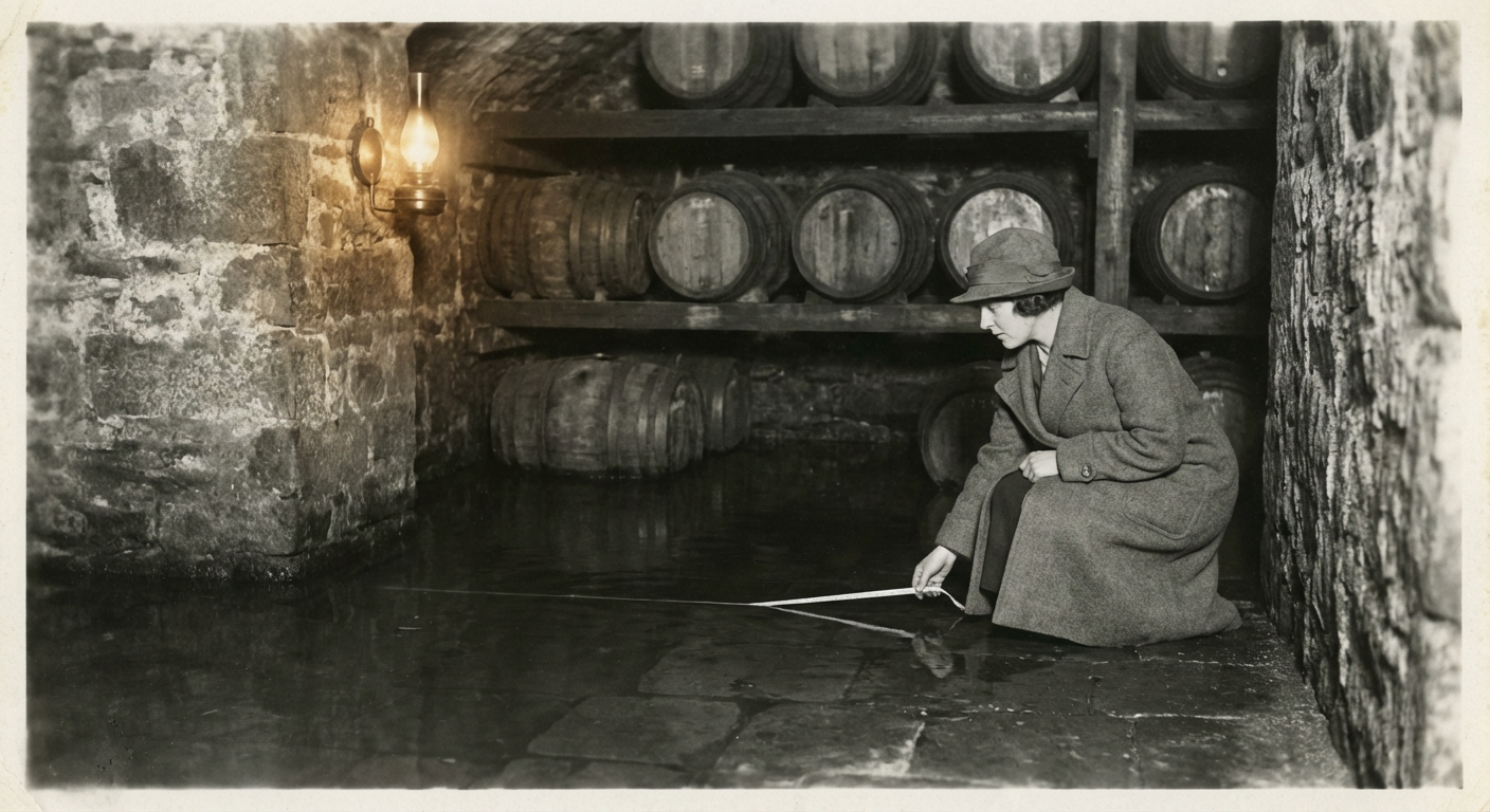
Miss Strand, the municipal surveyor who has spent the past six weeks mapping the Lower Conduit — the buried, unmapped waterway discovered beneath the Docklands in February — descended into Mr Penrose’s cellar with a tape measure, a water temperature probe, and her fourteenth field notebook.
Her conclusion was immediate.
“The cellar wall is approximately two metres from the conduit’s western branch,” she said. “The wall is original 1830s brickwork — lime mortar, no membrane, no modern waterproofing. The conduit has always been here. What has changed is the water level.”
The Lower Conduit, as traced by Miss Strand over recent weeks, extends 780 metres from its outfall beneath the old commercial wharf at Bramblegate Steps. At a junction approximately 340 metres from the outfall, it divides: the northeast branch runs to the known Ashwater outfall, while a newly discovered western branch runs northwest beneath the Bramblegate Market district toward the old brewery district — the area around Cooperage Lane where three breweries operated from the 1770s to the 1890s.
Miss Strand had traced 90 metres of the western branch before low roof clearance forced her to retreat. Mr Penrose’s cellar, she confirmed on Tuesday, sits directly above the conduit approximately 140 metres along the western branch — fifty metres beyond her previous furthest point.
“The conduit was almost certainly built to serve the breweries,” Miss Strand said. “Fresh water, channelled underground from a spring source. The eastern branch provided overflow to the river. When the breweries closed, the conduit continued to carry water — it just stopped mattering to anyone.”
The question is why the water level has risen. Miss Strand has three hypotheses: a partial blockage downstream, seasonal variation in the spring’s output, or — and here she paused — a change in the groundwater table possibly related to the same geological processes producing the Greymoor luminous phenomenon.
“That last one is speculative,” she said. “But the conduit draws from a deep aquifer, and we know the Greymoor system is thermally active. I am noting it, not asserting it.”
Mr Penrose listened to this explanation with the patience of a man whose primary concern is sixty barrels of winter ale.
“Can you fix it?” he asked.
“I am a surveyor, Mr Penrose, not a plumber,” Miss Strand replied. “But I can tell you where the water is coming from, and that is the first step toward stopping it.”
She spent three hours in the cellar, measuring the seam, probing the depth of the water table through the floor drain, and — with Mr Penrose’s permission — extracting a sample of the mortar from the eastern wall. The brickwork, she noted, is the same era and construction method as the conduit itself.
“This building was built by people who knew the conduit was here,” she said. “They built on top of it. They may even have used it — breweries need enormous quantities of water. The cellar drain connects to the conduit. It was not installed for rainwater. It was installed for this.”
Miss Strand intends to access the conduit through Mr Penrose’s cellar in the coming days, which would allow her to extend her survey of the western branch significantly beyond the previous 90-metre limit. Mr Penrose has agreed, on the condition that the ale is not disturbed.
The Lower Conduit heritage listing remains under review by the Municipal Heritage Committee. Miss Strand’s full survey report is expected at the end of March.